
Unique Partnership Delivers Critical Data to Those Who Are Protecting Coral Reefs From Decline
(Tempe, AZ) – The Allen Coral Atlas partners today announced that after three years, 450+ research teams and counting, and two million satellite images, the habitat mapping of the world’s shallow coral reefs is complete. Combined with the Atlas’ monitoring system launched earlier this year, the Allen Coral Atlas is now the most complete, consistent, accurate and continually updated resource for coral scientists, policy makers and regional planners.
Named for the late Paul G. Allen, Microsoft co-founder and philanthropist, the Allen Coral Atlas was developed and implemented through a partnership now directed by Arizona State University (ASU) Center for Global Discovery and Conservation.

“It is a gratifying milestone after years of dedicated non-stop teamwork to bring this global map to fruition, but the true value of the work will come when coral conservationists are able to better protect coral reefs based on the high-resolution maps and monitoring system,” said Dr. Greg Asner, Managing Director of the Atlas at ASU. “We must double down and use this tool as we work to save coral reefs from the impacts of our climate crisis and other threats.”
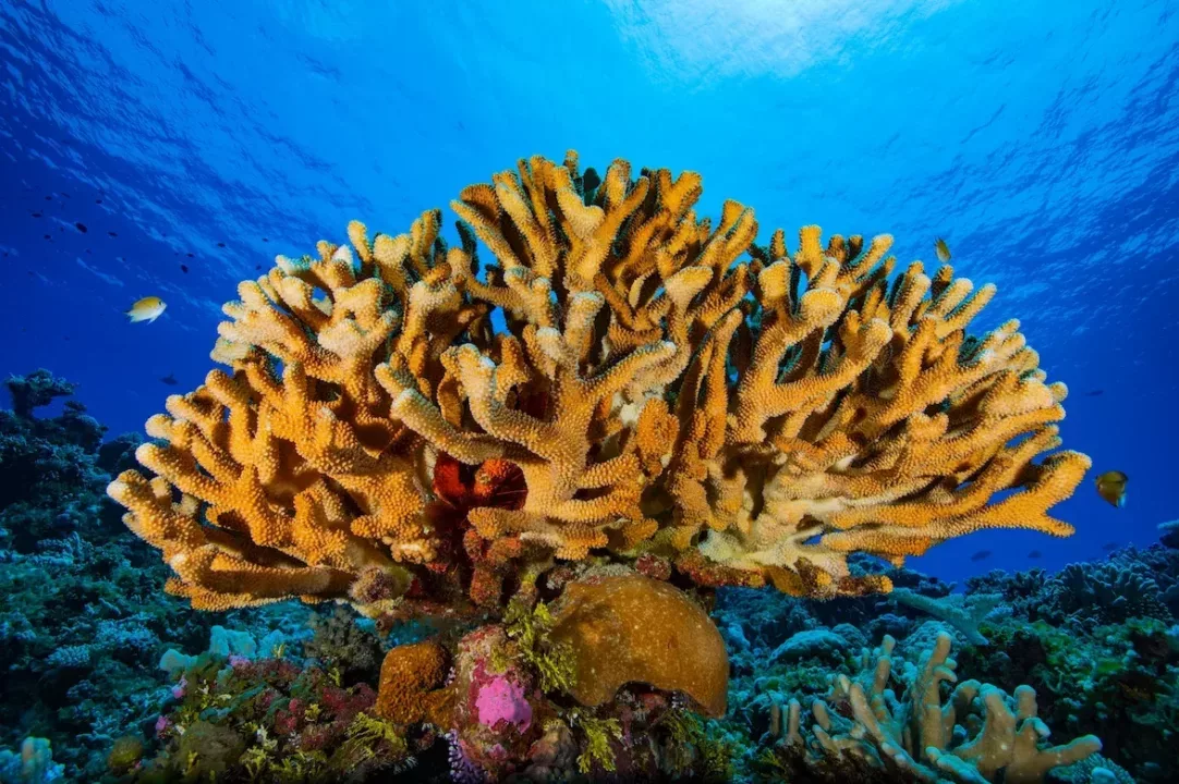
The future of coral reefs hangs in the balance, with 50 percent already lost to bleaching caused by increased water temperatures, ocean acidification, pollution and destructive overfishing. These highly vulnerable coral reef systems provide safety, nutrition and economic security for more than one billion people. Globally, scientists and governments are scrambling to plan and implement conservation efforts and they need accurate data on the location and status of their reefs.
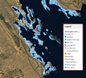
Using a consistent mapping process, the completed Atlas provides the first-ever, high-resolution spatial and thematic detailed map of all the world’s shallow coral reefs. Only 25 percent of reefs had been previously mapped at this high-resolution detail and there was no consistent methodology applied across all global regions.
“We now have the highly detailed coral reef maps needed to create new spatial plans and marine protected areas. These map layers would have taken us five years to create and only if we had the budget or resources to do so, which we do not,” said Wen Wen, a marine spatial planner in Indonesia. “The Allen Coral Atlas is playing a large role in prioritizing 30 million hectares of a new Marine Protected Area zoning plan and providing alternative locations for a coastal economic development project that is environmentally sustainable. This tool is a blessing to our country.”
The Atlas partnership brings together unique capabilities to create a seamless process that produces high quality benthic and geomorphic map layers. Planet provides continuously updated high-resolution imagery from its constellation of 200+ satellites. ASU then cleans the images for atmosphere and water distortion. University of Queensland applies machine learning and local reference data to generate the detailed map layers, and National Geographic Society provides training and engages with conservationists on how to best use the maps. Paul Allen’s company Vulcan funded and managed the Atlas website development and engaged with government officials.
Officials from 14 countries are collaborating with Atlas team members, working on 48 new marine planning projects using the Atlas maps as their foundational data set. In addition to marine spatial planning, the maps are being used to aid in hurricane recovery, to inform proposed policies for fishing regulations, identify pollution and run-off sources, and document destruction due to ship groundings and other threats to coral reef habitats.
“Combining these new maps with the reef bleaching detection system that we released in May, the Atlas is a vital, comprehensive tool,” said Asner. “It is a dynamic, global resource available to marine managers, conservationists and policy makers who can take action to safeguard coral reefs for generations to come.”

Read more about this achievement from the Allen Coral Atlas here